4.1 - Geology of the North Sea
Fig-4-001
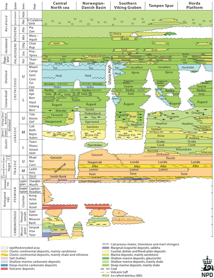
Fig-4-002
Lithostratigraphic chart of the North Sea (NPD)
Fig-4-003
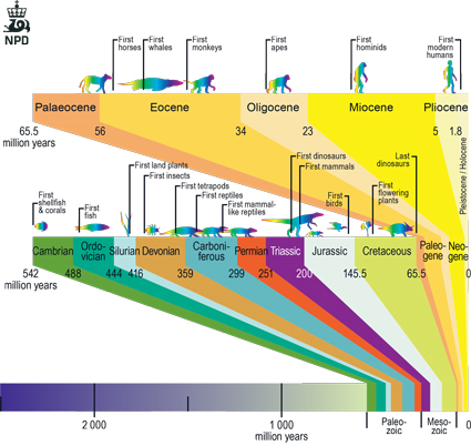
Fig-4-004
Geological time scale
The basic structural framework of the North Sea is mainly the result of Upper Jurassic/ Lower Cretaceous rifting, partly controlled by older structural elements.
Carboniferous-Permian: Major rifting with volcanism and deposition of reddish eolian and fluvial sandstones (Rotliegendes). Two basins were developed with deposition of thick evaporate sequences (Zechstein). When overlain by a sufficient amount of younger sediments, buoyancy forces caused the salt to move upwards (halokinesis). This is important for generation of closed structures, including hydrocar-bon traps, in the southern part of the North Sea and also as a control on local topography and further sedimentation.
Triassic: Major N-S to NE-SW rifting with thick coarse fluvial sediments de-posited along rift margins, grading into finer-grained river and lake deposits in the center of the basins. The transition between the Triassic and Jurassic is marked by a widespread marine trans-gression from north and south.
Jurassic: The marine transgression was followed by the growth of a volca-nic dome centered over the triple point between the Viking Graben, the Central Graben and the Moray Firth Basin. The doming caused uplift and erosion, and was followed by rifting. Large deltaic systems containing sand, shale and coal were developed in the northern North Sea and the Horda Platform (Brent Group). In the Norwegian-Danish Basin and the Stord Basin, the Vestland Group contains similar deltaic sequences overlain by shallow marine/marginal marine sandstones. The most important Jurassic rifting phase in the North Sea area took place during the Late Jurassic and lasted into the Early Cretaceous. During this tectonic epi-sode, major block faulting caused uplift and tilting, creating considerable local topography with erosion and sediment supply. In anoxic basins thick sequenc-es of shale accumulated, producing the most important source rock and also the Draupne Formation, which is an important seal for hydrocarbon traps in the North Sea area.
Cretaceous: The rifting ceased and was followed by thermal subsidence. The Upper Cretaceous in the North Sea is dominated by two contrasting lithologies. South of 61o N there was deposition of chalk, while to the north the carbonates gave way to siliclastic, clay-dominated sediments.
Cenozoic: In the Paleocene/Eocene there were major earth movements with the onset of sea floor spreading in the north Atlantic and mountain build-ing in the Alps/Himalaya. In the North Sea, deposition of chalk continued until Early Paleocene. Uplift of basin margins, due to inversion, produced a series of submarine fans transported from the Shetland Platform towards the east. These sands interfinger with marine shales in both the Rogaland and the Hordaland Groups. In the Miocene a deltaic system had developed from the Shetland Platform towards the Norwegian sector of the North Sea, and is represented by the Skade and Utsira Formations. Due to major uplift and Quaternary glacial erosion of the Norwegian mainland, thick sequences were deposited into the North Sea during the Neogene. This led to burial of the Jurassic source rocks to depths where hydrocarbons could be generated and the seals were effective.
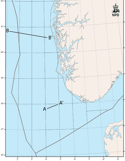
Fig-4-005
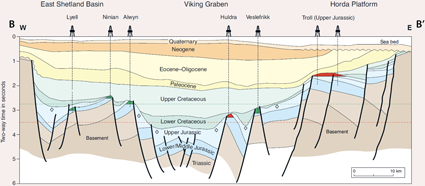
Fig-4-006
Geoseismic cross section in the northern North Sea.
From the Millennium atlas 2001
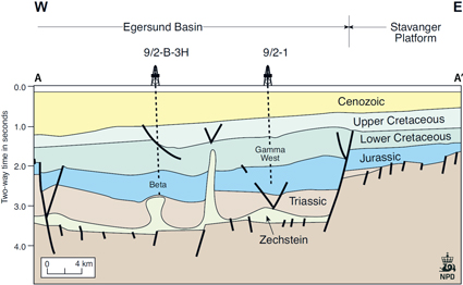
Fig-4-007
Geoseismic cross section in the Egersund basin.
From the Millennium atlas 2001
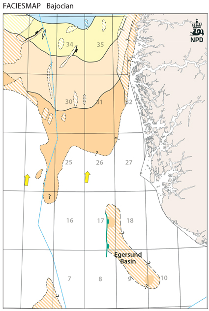
Fig-4-008
This map displays the development of the Brent delta and the early stage of the deposition of the Bryne Formation. The map to the right shows the development of the Sognefjord delta and the Sandnes and Hugin Formations after the Brent delta was transgressed.
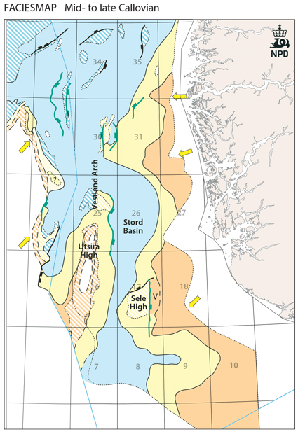
Fig-4-009
Examples of mid Jurassic relationship between continental and marine deposits in central and northern North Sea. Continental sediments in brownish colour, shallow marine in yellow and offshore marine in blue.

Fig-4-010
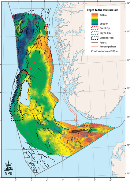
Fig-4-011
Mapping of the upper and middle Jurassic forms the basis of many of the following depth and thickness maps of assessed geological formations. The top Jurassic refers to the top of Upper Jurassic sandstones or their equivalents.
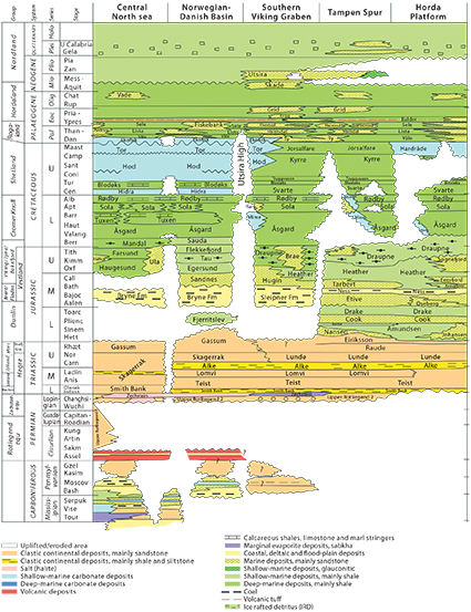
Fig-4-012
Liks
- The Statfjord Group
- The Dunlin Group
- The Dunlin Group - Johansen Formation
- The Brent Group
- The Viking Group
- The Hegre Group - Skagerrak Formation
- The Gassum and Fjerritslev Formations
- The Vestland Group The Vestland Group - Sleipner Formation
- The Vestland Group - Hugin Formation The Vestland Group - Bryne Formation
- The Vestland Group - Sandnes Formation
- The Vestland Group - Ula Formation The Boknfjord Group
- The Rogaland Group
- The Hordaland Group - Skade Formation
- The Nordland Group - Utsira Formation
- The Hordaland Group - Claystones