Additional aquifers and Seal Capacity
Fruholmen Formation
The sandy parts of the Fruholmen Formation were deposited in large parts of the evaluated area in a fluvio-deltaic environment. The channelized sandstones have good reservoir properties along the basin margins where they are not too deeply buried. In the 7125/4-1 discovery of the Goliat field, these sandstones have trapped oil. The Fruholmen Formation is not evaluated as an aquifer with large injection potential, since the lateral connectivity is uncertain. On a regional scale, the formation may contribute to the aquifer volume of the overlying Realgrunnen Subgroup aquifer.
Snadd Formation
The sandstones in the Snadd Formation are separated from the sandy part of the Fruholmen Formation by a shale section (Akkar Member) which acts as a regional seal. Channelized sandy systems are widely distributed in the Snadd Formation, and can be mapped on 3D seismic data. Gas accumulations have been encountered in a few wells. The Snadd formation has not been evaluated for large scale CO2 injection, due to poor lateral connectivity and because several of the undrilled channel sandstones may have a potential for hydrocarbons.
Kobbe Formation
The Kobbe Formation consists of marine shales, silts and deltaic sands, mainly fine to medium grained. The formation is developed as reservoir sandstones along the Troms-Finnmark fault zone as described in section 6.1. The Kobbe Formation constitutes the main reservoir in the Goliat Field. It has not been evaluated for large scale CO2 injection because only a limited volume of the aquifer is buried at sufficiently shallow depth to maintain high porosity and permeability.
Late Paleozoic reservoirs
Late Paleozoic sandstones and carbonates and Early Triassic sandstones outcrop along the coast of Troms and Finnmark south of the evaluated area. Reservoir properties have been proved by a few exploration wells and stratigraphic cores. Because of limited seismic and well data coverage close to the coast, no attempt was made to map potential prospects for CO2 storage.
Sealing properties
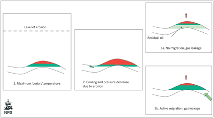
The Jurassic reservoirs in the Hammerfest Basin and Bjarmeland Platform have thick zones with residual oil and oil shows. The distribution of oil in the Hammerfest Basin indicates that the main structural closures in the central part of the basin were filled with oil and gas to spill point in the past. The gas has seeped or leaked out of the structures, while most of the oil may be preserved as residual oil down to the paleo oil-water contact. This setting is important for the evaluation of the properties of the sealing rocks. There are two important questions:
- What is the typical rate of methane seepage from gas filled structures in the Barents Sea ?
- What will be the rate of seepage from a plume of CO2 in dense phase compared with a methane seepage ?
Methane seepage is commonly observed on seismic data and on the seabed at the NCS, in particular in areas of active hydrocarbon generation. In the studied area, gas chimneys and shallow gas are seen on seismic data in the Bjørnøya Basin and the western part of the Hammerfest Basin. In the Bjørnøya Basin, gas chimneys are commonly capped by gas hydrates and associated with gas flares (Chand et al. 2012). This shows that gas seepage is active today. The most active seepage takes place in the Bjørnøya Basin and the Bjørnøyrenna Fault Complex. Here, the source rocks generate hydrocarbons, and several traps are filled to spill point. This indicates that the rate of gas seepage is slower than, or in equilibrium with, the rate of gas generation. Consequently, this is interpreted as a slow process related to a time scale of hundreds or thousands of years, which is the time scale of interest for CO2 sequestration. Concerning the sealing capacity for CO2 compared to methane, the case of well 7019/1-1 shows that the Upper Jurassic seal in this well is capable of maintaining a 30 bar pressure difference between the 50% CO2/methane mixture in the Jurassic reservoir and the methane with 10-15% CO2 in the Cretaceous reservoir. Our interpretation is that in this well, the rate of seepage of CO2 is significantly lower than for methane. These observations and interpretations are used in the characterization of the sealing rocks. The conclusion is that one can use the same guidelines for the Barents Sea as for the North Sea and the Norwegian Sea. There is, however, a concern that some types of cap rocks and some structural settings could have been influenced by the unloading and cooling processes to become more fractured, and consequently have a reduced sealing capacity.