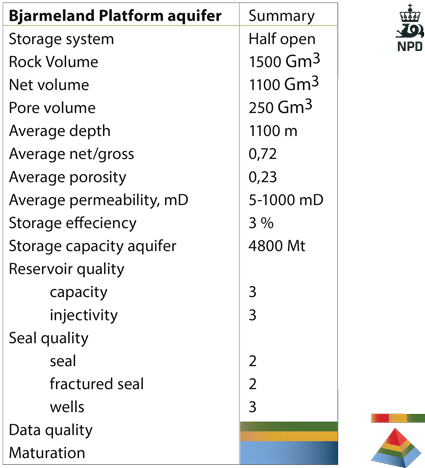
Bjarmeland Platform
The Bjarmeland Platform is located north of 72°N and extends beyond 74°N, north of the Nordkapp Basin. Ten exploration wells and some shallow stratigraphic wells are drilled (by 2013) in the larger area of the Bjarmeland Platform including the western part towards the Loppa High.
A condensed Lower and Middle Jurassic section is developed in large areas in the central Barents Sea and Svalbard. In the Bjarmeland Platform the thickness of the Realgrunnen Subgroup decreases from around 100 m in the south to a few tens of metres in the north. The sedimentary facies are similar to the Tubåen, Nordmela and Stø Formations in the Hammerfest Basin. The boundary between the Hammerfest Basin aquifer and the Bjarmeland Platform aquifer is transitional.
According to well data, the best quality aquifer in the Bjarmeland Platform is found in the saddle area between the Nordkapp and Hammerfest Basins. The structuring of the Bjarmeland Platform is mainly related to salt tectonics which has resulted in domes, rim synclines and normal faults. In the northern part of the platform and towards the Loppa High and the Svalis Dome in the west, the Jurassic strata are eroded and Triassic sedimentary rocks outcrop at the seabed. The Quaternary thickness is generally less than 100 m along the subcrop lines.
The pore pressure is hydrostatic. It is likely that the degree of communication within the regional Bjarmeland Platform aquifer is not as good as within the upper part of the Hammerfest Basin aquifer (Stø Formation), due to reduced thickness and more heterolithic facies.
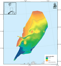
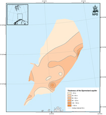
Fig-6-062
Depth map and thickness map of the Bjarmeland Platform aquifer which consists of the Realgrunnen Subgroup.