Introduction
The parts of northern Fennoscandia adjacent to the Norwegian sector of the Barents Sea are sparsely populated, and the industrial activity generates only small amounts of CO2 emissions. CO2 associated with the production of natural gas in the Snøhvit Field is extracted at Melkøya, Hammerfest, and injected in the aquifer of the field. CO2 associated with gas production is believed to be the main source for CO2 storage and EOR in the near future. In a more distant future, storage of anthropogenic CO2 from industrial activity may become an option.

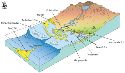
Fig-6-054
Conceptual sketch showing the depositional environments of the different aquifers.
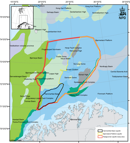
For detailed evaluation of storage capacity, large areas in the north and east were eliminated. The areas north of 74° were excluded because they were considered too remote and because the good Jurassic aquifers are generally thin and poorly sealed due to a shallow overburden. The Finnmark Platform east of 29° was eliminated because there is limited infrastructure and industrial activity in this area, and the main aquifers of interest are poorly structured and generally dipping with only a Quaternary seal towards the sea floor. The area selected for detailed evaluation of storage capacity is shown in the map. The petroleum systems of the Barents Sea are more complex than in the North Sea and Norwegian Sea. Important source rocks occur in the Upper Jurassic, Middle Triassic and Late Paleozoic sections. Because of Cenozoic tectonism and Quaternary glacial erosion, the maximum burial of these source rocks in the evaluated area occurred in the past. The reservoir porosity and permeability are related to the temperature and pressure at maximum burial. Due to extensive erosion, good reservoir quality is encountered only at shallower depth than what is found in the North Sea and Norwegian Sea. Below 3000 m the porosity and permeability is generally too low for large scale injection.
The Cenozoic history has also affected the distribution of hydrocarbons in the evaluated area. Residual oil is very commonly found, both in water-bearing traps and below the gas cap in gas-bearing traps. Hydrocarbons and traces of hydrocarbons have been found in several aquifers, and at the present stage in exploration, it is thought that most of the area selected for evaluation of CO2 storage will also be subject to further exploration and exploitation by the petroleum industry. Consequently, storage of CO2 in the southern Barents Sea must take place in accordance with the interests of the petroleum industry. The main storage options considered in this study are limited to structurally defined traps, and to depleted and abandoned gas fields. In areas where the pressure exceeds the miscibility pressure of CO2 and oil, one might consider using CO2 injection to recover some of these oil resources (CCUS).
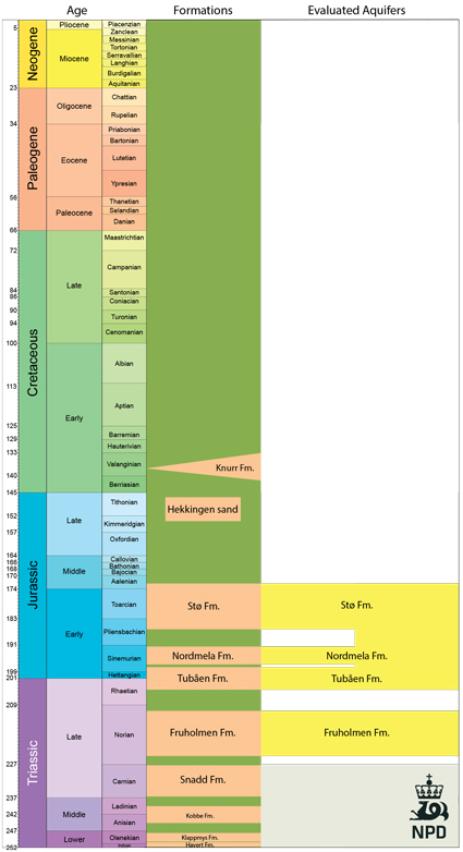
The main aquifer system in the study area consists of Lower and Middle Jurassic sandstones belonging to the Realgrunnen Subgroup. This aquifer system can be defined in three distinct geographical areas which are described in the following section. Hydrocarbons have been encountered in several reservoir levels pre-dating the Jurassic, notably in the Late Triassic Fruholmen and Snadd Formations, the Middle Triassic Kobbe Formation and in Permian carbonates and spiculites, thus proving there is a reservoir and seal potential for these formations. Their storage potential is not as promising as for the Jurassic aquifer and is only briefly discussed. Upper Jurassic and Lower Cretaceous sandstones are limited to the flanks of active highs and do not form major aquifers. Eocene reservoir sandstones have been encountered in two wells in the western margin of the Barents Sea, but they are not considered for this study.

Fig-6-055
The evaluated area (red outline).
The Jurassic aquifers are eroded in the Loppa High.
