
Maintaining an overview of petroleum resources across the whole Norwegian continental shelf (NCS) is one of the duties of the Norwegian Petroleum Directorate (NPD). The NPD therefore works to map possible petroleum resources in both opened and unopened areas of the NCS in order to secure a good factual basis for future decisions. This work is entrenched in the letter of allocation to the NPD – the section dealing with working for long-term resource availability – and the directorate’s strategic plan for 2016-20 on mapping and promoting the resources.
Introduction and summary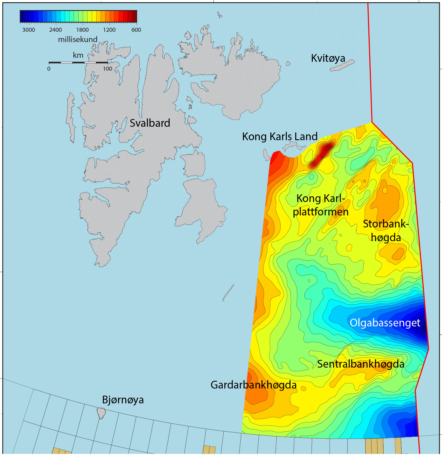
The NPD has worked since 2012 on mapping Norway’s continental shelf in the eastern part of Barents Sea North. See figures 1 and 2. This area has not been opened for petroleum activities, and is defined by the boundary line to the east, 74°30’N to the south, 25°E to the west, and Edgeøya and Kong Karls Land to the north-west and north respectively – an area of about 170 000 square kilometres. (By comparison, the Norwegian sector of the North Sea covers about 160 000 square kilometres.)
Petroleum activity
Areas of the Barents Sea which have been opened for petroleum operations are frequently designated Barents Sea South, delineated by latitude 74˚30’N. The Barents Sea contained 71 production licences at May 2017. Licence awards began in 1980, and the first well was drilled in the same year. A total of 157 wells have so far been drilled in Norway’s Barents Sea sector, including 126 for exploration. Forty-nine discoveries were made in these waters from 1980 to 2016. The first of these, 7120/8-1 Askeladd (today part of the Snøhvit field), was found in 1981.
Database
The NPD has used both new and older data sets in mapping eastern parts of Barents Sea North. It acquired some 70 000 kilometres of 2D seismic lines in Barents Sea North during 1973-96. While the quality of many older data sets is poor, they can provide useful and complementary information when combined with new surveys. The NPD acquired 32 600 kilometres of new 2D seismic data in the area during 2012, 2013 and 2014, primarily in the eastern part. It also acquired some 6 000 kilometres of 2D seismic in 2016. Processing of these data had not been completed at the time of writing, but they will be incorporated in the continued evaluation
Structural and stratigraphic overview of Barents Sea North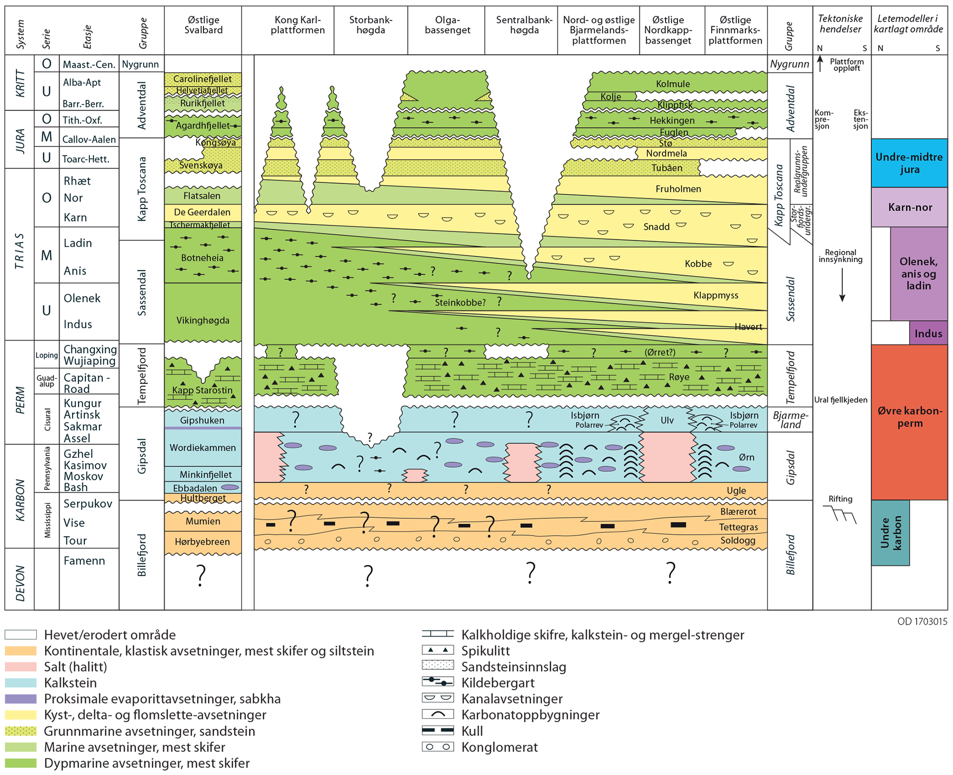
The Barents Sea is divided into geological basins, platforms and highs, collectively designated structural elements. This region contains a more or less continuous succession from the Upper Palaeozoic to the Eocene. In the mapped eastern part of Barents Sea North, the succession has been eroded from the Upper Cretaceous, and the Quaternary sedimentary package is very thin. Triassic strata outcrop on the largest highs.
Petroleum geology
A series of discoveries in both Norwegian and Russian sectors of Barents Sea South show that a number of petroleum systems work in the area. Nevertheless, uncertainty exists with a number of factors. For hydrocarbons to be formed and accumulated in an area, several geological factors must coincide. If one or more of the factors mentioned above are absent, accumulated quantities of oil and gas will not be found in the area. Uncertainty always prevails about the presence of hydrocarbons in a mapped prospect, and exploration wells must be drilled to determine the matter.
Plays
A confirmed play will mean that uncertainty no longer prevails about the three geological factors. When a play has been confirmed, the resource estimate associated with it will rise because the probability of success has increased. The relationship between basin, play. Several plays can be found in a single geographical area. These could, for example, vary in their geological age and thereby lie over each other at different levels in the sedimentary succession.
Resource evaluation
As mentioned above, the NPD has conducted shallow stratigraphic drilling in the area and the evaluation of these boreholes is continuing. They lie a very considerable distance from exploration wells in the southern Barents Sea. Many parameters used in the resource estimates are therefore highly uncertain. Future exploration drilling in Barents Sea South and in the Russian sector, and more detailed mapping in Barents Sea North, could change the view of expected volume and fluid parameters. In addition to reducing the uncertainty range
Summary and conclusion
Expected recoverable resources in eastern parts of Barents Sea North are calculated to be 1 370 million scm oe, with a downside of 350 million scm oe (P95) and an upside of 2 460 million scm oe (P05). Possible drilling and confirmation of one or more plays will move these estimates towards the higher values. Expected recoverable resources break down into 825 million scm of fluids and 545 billion scm of gas. The fluid/gas relationship helps to distinguish the area from Barents Sea South. While gas is estimated to represent the largest proportion (60 per cent) in the south, liquids account for the biggest share (60 per cent) here.