Petroleum geology
A series of discoveries in both Norwegian and Russian sectors of Barents Sea South show that a number of petroleum systems work in the area. Nevertheless, uncertainty exists with a number of factors. For hydrocarbons to be formed and accumulated in an area, several geological factors (see fact box) must coincide.
If one or more of the factors mentioned above are absent, accumulated quantities of oil and gas will not be found in the area. Uncertainty always prevails about the presence of hydrocarbons in a mapped prospect, and exploration wells must be drilled to determine the matter.
Geological factors
- A source rock is present containing organic materials which are converted to hydrocarbons under temperature and pressure.
- A migration route allows the hydrocarbons to flow from the source rock to the reservoir rock.
- A reservoir rock is present to provide a porous/ permeable structure where hydrocarbons can be retained.
- A cap rock has formed as an impermeable layer encasing the reservoir rock so that the hydrocarbons are retained and accumulate in the reservoir.
SOURCE ROCKS
Petroleum systems in the Barents Sea comprise a number of possible source rocks (figure 13) (Ohm et al, 2008; Lerch et al, 2016). These source rocks are of various types and differ in their potential for forming hydrocarbons. Some will mainly generate gas, while others are more likely to form oil.
Lower Carboniferous coal and carbonaceous shale (the Billefjorden Group) are regarded as potential source rocks in the evaluated area. Geological developments in the evaluated area indicate that this source has been deeply buried, and is very likely to be gas generating in today’s basin areas. On the highs, this source rock is rather shallower – increasing the probability that oil will be generated should it be present. Because of their depth and the lack of outcropping strata, the deep source rocks cannot be sampled with shallow drilling in and close to the evaluated area. Assumptions about this source are therefore based on information from Svalbard and from exploration wells/shallow drilling in Barents Sea South.
Upper Carboniferous and Lower Permian organic carbonate-rich mud (Gipsdalen Group) and Upper Permian marine shale (Tempelfjorden Group) may also have a source potential. Among the oldest source rocks, the organic carbonate-rich mud of the Upper Carboniferous and Lower Permian (Gipsdalen Group) is considered to have the biggest oil-generating potential. Owing to erosion and/or lack of deposition, particularly over highs, the presence of the Tempelfjorden Group is uncertain in parts of the area. Furthermore, depth of burial with associated high temperatures provides a substantial probability that the source(s) are gas generating – particularly in deeper areas. Assumptions about this source rock are based on information from Svalbard and from exploration drilling/shallow boreholes in Barents Sea South.
The most important source rock in Barents Sea North is assumed to be organically rich Olenekian, Anisian and Ladinian shales (the Steinkobbe/Botneheia Formation). The Steinkobbe Formation is a proven oil-generating source in Barents Sea South (Lundschien et al, 2014), and is assumed to be developed as a good source rock in parts of the mapped area. The Steinkobbe Formation is time transgressive and transitions into the Botneheia Formation towards the north-west. Steinkobbe/Botneheia is assumed to be present over large parts of the evaluated area. Geochemical analyses at Blanknuten in Edgeøya indicate that the Botneheia Formation is oil generating (Abay et al, 2014). Geological interpretation of the seismic data indicates that Steinkobbe/Botneheia has been/is buried at a favourable depth for oil generation.
In addition to the above-mentioned source rocks, source rock potential could be present at other levels – such as in the Early and Late Triassic. Organic-rich Late Jurassic shale (the Hekkingen Formation in the Barents Sea), which usually represents the most important source interval on the NCS, is probably immature throughout the area.
Conversion of organic material in source rocks to hydrocarbons depends on its burial to a depth with a sufficiently high temperature. The latter rises as the source rocks become more deeply buried. Once deep enough, the rocks will generate oil and are described as oil-mature. Further subsidence and higher temperatures will cause the rocks to generate gas. If the temperature continues to rise, the hydrocarbon potential in the organic material disappears and the source rock becomes exhausted. Large quantities of hydrocarbons are likely to form at temperatures around 120°C, and these can leave the source rock to migrate into traps.
This process requires the presence of permeable geological strata or fractures which connect the source rock with the trap. A critical factor in assessing the petroleum potential of the prospects is whether the migration process has functioned.
The temperature required to form hydrocarbons depends on the quality of the source rocks and how much time has passed. On the NCS, the temperature will typically rise about 35°C per kilometre of buried depth, but this varies somewhat from area to area. Because of the erosion mentioned in the section below on hydrocarbon retention, maximum burial and thereby maximum temperature has been higher than today’s depth would suggest. In other words, the potential of possible source rocks for generating oil and gas has altered between various periods because their burial depth has changed over time.
RESERVOIR ROCKS
Several factors govern deposition and preservation of reservoir rocks. The original deposition environment is important for reservoir properties and, because the mapped area covers a large area, this will vary across it. A common denominator for all reservoirs is that burial depth is an important factor for preservation of their properties over time. If they are buried too deep, their porosity and permeability – and thereby flow properties for hydrocarbons – will deteriorate. Ultimately, these will be so reduced that the rock can no longer be regarded as a suitable source.
A number of different reservoir rocks exist, and both sandstone and carbonate formations are relevant in the evaluated area. They are described in the section on the various plays. When estimating reservoir properties, changes in these over time are particularly affected by maximum burial depth and temperature. In the mapped region, Middle and Upper Triassic as well as Jurassic sandstone reservoirs will lie at favourable depths. This makes it likely that their properties have been preserved over large areas. Uncertainty over preserved reservoir properties is greater for deeper levels in the Lower Triassic and the Carboniferous- Permian. Upper Carboniferous-Permian carbonates are expected to lie at shallower depths in the north than in the south, which increases the probability that reservoir properties are preserved. Opportunities are also present for secondary porosity arising from diagenesis or fracturing after the rock was formed. Nor can fractured or deteriorated basement rock be excluded, but it has not been included in this study.
TRAPS
A large number of structural traps have been mapped in the area. Several of these are very large, since their extent and thereby the volume of rock they contain are substantial. Nevertheless, it must be noted that the traps are not assumed to be filled to the spill point when estimating the resources, and that a maximum hydrocarbon column of 300 metres is used as the cut-off. This restriction is based on experience from Barents Sea South, where the traps often show signs of leakage and where the maximum proven hydrocarbon column is in the order of 250 metres.
Traps are structures which can contain hydrocarbons because they are bounded by tight (impermeable) rocks which prevent or restrict further hydrocarbon migration. Structural traps comprise a bounded isolated high, while stratigraphic traps consist of isolated reservoir rocks surrounded by tight rocks.
Anticlines and fault blocks, which are both examples of the structural type, dominate among the traps. In addition, the possibility of stratigraphic traps cannot be excluded.
The sealing potential in the Barents Sea is often regarded as challenging, particularly for the shallowest reservoirs. Nevertheless, structures in the Pechora Basin – where faults extend to the seabed but the trap continues to function – show that local factors and properties related to lithology could allow the seal to hold (Henriksen et al, 2013). In addition, the Wisting discovery in 7324/8-1 (figure 4) at a depth of 662 metres shows that sealing can function even with a shallow reservoir.
RETENTION OF HYDROCARBONS IN A TRAP
Erosion of sedimentary successions across large parts of the Barents Sea over the past 66 million years is estimated at 1 000-1 500 metres or more, and has been up to 3 000 metres in some areas (Henriksen et al, 2013). These estimates build particularly on geochemical analyses of the conversion of organic material and on compaction and cementing of the reservoir rocks. Temperature and pressure in the petroleum systems are therefore lower today than would have been the case for maximum burial. This must be taken into account when evaluating such aspects as reservoir quality, source potential and migration. The effects of uplift and erosion on prospectivity, and dating these processes, have been discussed for many years. Indications of several different tectonic episodes are to be found in the Barents Sea area, and agreement by and large prevails that uplift in the Palaeogene and glaciation in the Neogene affected the whole region. (Riis & Fjeldskaar, 1992; Henriksen et al, 2013).
Erosion causes the temperature of the source rocks to fall, so that maturation ceases or is substantially reduced. Furthermore, the pressure reduction from the load removal will cause the gas zones to expand and allow gas to bubble out of the oil zones. Areas subject to uplift could experience substantial alterations in the direction of petroleum migration, and great uncertainty prevails about these changes and the directions the oil and gas will take.
During the early exploration phase in the Barents Sea, it was established that porosity values in the reservoirs were far lower than their present burial depth would indicate. This suggested that the sedimentary succession has been buried considerably deeper. Maximum burial depth is calculated by analysing the alteration of minerals and organic materials in the sediment. This is routinely done for all exploration wells in the Barents Sea (Ohm et al, 2008).
Such data also exist from shallow boreholes in the northern Barents Sea and from field studies in Svalbard.
Exploration activity in Barents Sea South revealed at an early stage that proven discoveries were not filled to the spill point of the structures. Traces of oil and gas have also been found in a great many dry wells (Lerch et al, 2016), indicating that petroleum has leaked out. Erosion and faulting through and over the structures constitute a risk of increased leak rates (Henriksen et al, 2013).
Some 1-2 000 metres of the overburden on the rocks could have been eroded in the mapped area, but some uncertainty exists about these estimates. Uplift and consequent pressure reduction could lead to reactivation of faults and fracturing in the cap rock and thereby to leakage. Furthermore, temperature reductions could also cause fracturing in the cap rock, which in turn enhances the leakage risk.
Risk related to retention is one of the main challenges in the evaluated area, where faults sometimes extend all the way to the base of Quaternary strata. That applies not least where the temperature of the source rock has fallen so much that it can no longer contribute newly formed hydrocarbons to the traps. The observations cited above demonstrate that erosion owing to uplift and glaciation has had a big effect on the petroleum system and possible petroleum deposits in the Barents Sea. Detailed evaluations of these factors should therefore be made when assessing prospectivity and as part of future work in Barents Sea North.
HYDROCARBON INDICATIONS
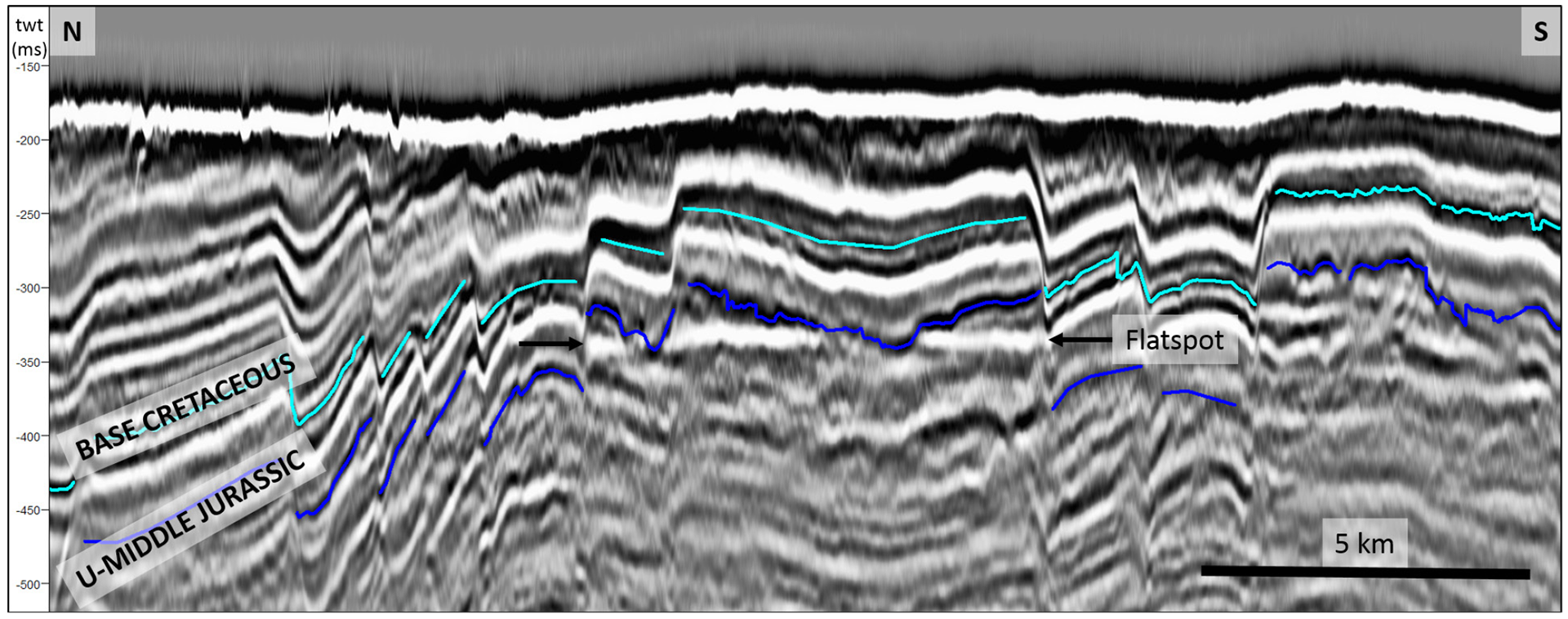
A number of the anticlines with traps on the Kong Karl platform and the flanks of the Storbanken high (figure 2) show increased seismic amplitude (figure 25). A flat spot in Lower-Middle Jurassic rocks on the edge of the Storbanken high could indicate the presence of hydrocarbons in the strata concerned (figure 26). These observations suggest an active petroleum system in the area.
Figure 25.
Compression anticlines on the Kong Karl platform. A general feature of the Jurassic package in the mapped are is its shallowness. The anticline on the right represents a large Jurassic trap in the mapped area. Erosion at the top of the structure appears to be down or very close to Late Jurassic shales. Despite the erosion and little overburden, an increase in amplitude has been observed in several of the anticlines on and below the reflector interpreted as the top of the sandstone succession from the Early-Middle Jurassic.