Plays
Estimating possible petroleum resources in an area builds on a good understanding of the regional geology. In an area without previous exploration activity, uncertainty will be particularly great with regard to the:
- total resources
- geographical distribution of the resources
- size distribution (large or small deposits) and number
- division between the oil and gas resources
Assessments of possible plays (see the fact box below) are based on the method used to estimate possible petroleum resources. The probability that the factors described in figure 23 are present is assessed for each play. Summing probabilities for these three factors yields the play probability. This describes the level of uncertainty about whether the play functions before a discovery is made in it. At least one discovery is required to confirm that a play functions. This discovery does not have to be commercial.
Play |
|
Play: a geographically delineated area where several geological factors are present so that producible petroleum could be proven. These factors are:Reservoir rock, a porous rock where petroleum can accumulate. Reservoir rocks in a specific play will belong to a given stratigraphic level (age). Cap rock, a tight (impermeable) rock overlaying a reservoir rock, so that petroleum can migrate no further and accumulates in the reservoir. The resulting trap must have formed before petroleum ceased to migrate into the reservoir. Source rock, shale, limestone or coal containing organic materials which can be converted into petroleum. The source rock must also be mature – in other words, have a temperature and pressure such that petroleum actually forms – and the petroleum must be able to migrate from source rock to reservoir rock. |
A confirmed play will mean that uncertainty no longer prevails about the three geological factors. When a play has been confirmed, the resource estimate associated with it will rise because the probability of success has increased. The relationship between basin, play, prospect and discovery is illustrated in figure 27.
Several plays can be found in a single geographical area. These could, for example, vary in their geological age and thereby lie over each other at different levels in the sedimentary succession.
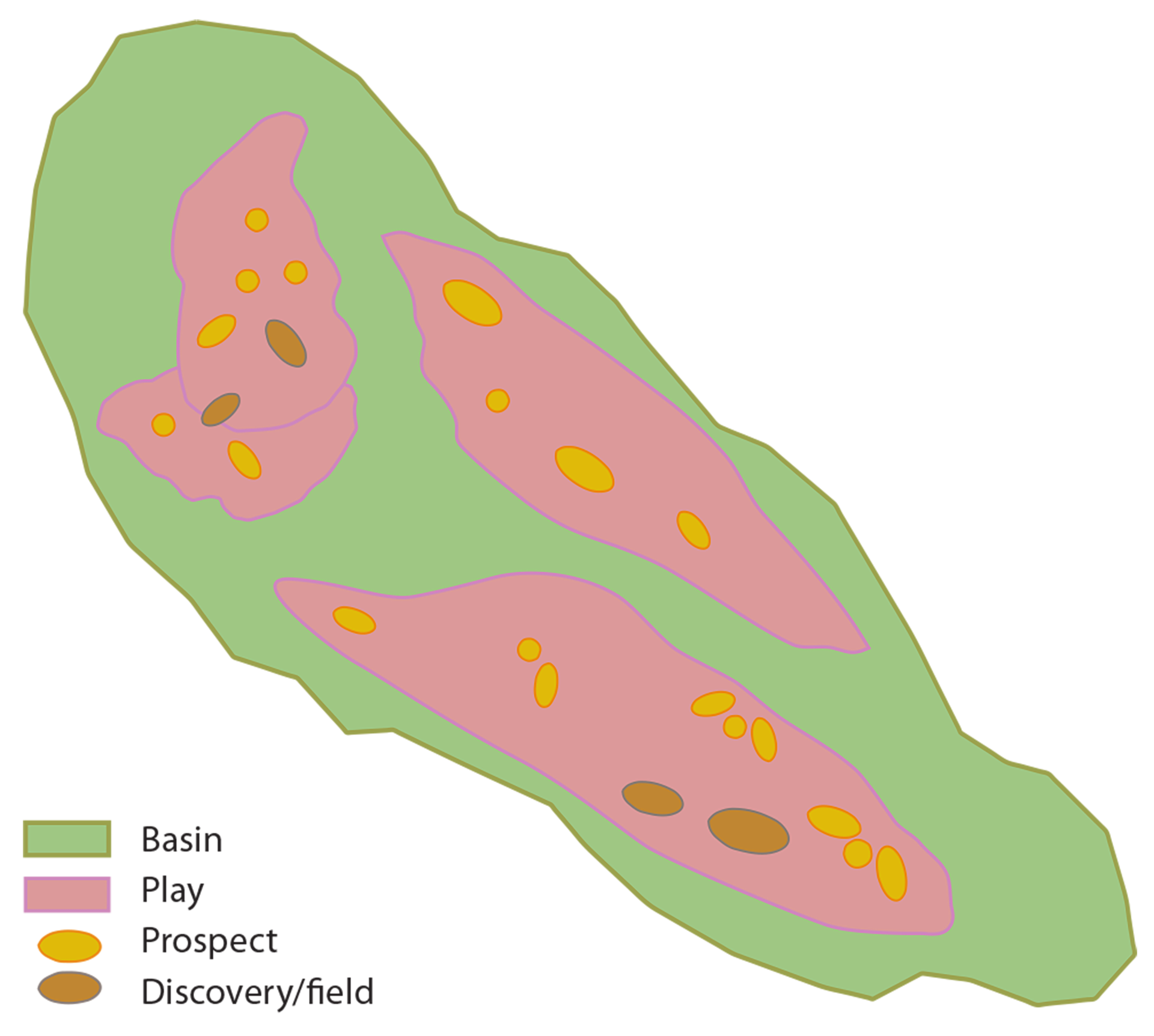
Figure 27:
The relationship between basin, play, prospect and discovery.
PLAY ANALYSIS – METHOD FOR CALCULATING POSSIBLE PETROLEUM RESOURCES
Several methods are available for estimating how much oil and gas might have been formed and retained in an area. The choice of method depends in part on how much is known about the area. Play analysis is a stochastic calculation method used by the NPD to produce resource estimates for the NCS.
This involves systematising and grouping the geological parameters which characterise the play, and which distinguish it from others. The estimated resources are risk-weighted – in other words, the estimated volume is multiplied by the probability of success. Whether a play contains petroleum is uncertain until a discovery has been made. If no mobile petroleum is proven in a prospect belonging to the play, the latter remains unconfirmed. An unconfirmed play is one where uncertainty prevails about one or more of the geological factors which must be present in order to discover petroleum.
Play analyses utilise a stochastic calculation model, where in-place and recoverable resources are calculated with their associated uncertainty range. The simulations in the analyses take account of the probabilities of success. When aggregating these, account is taken of possible interdependencies in volume and risk parameters and Monte Carlo Simulation is used to sample stochastically in all uncertainty distributions.
Even when a play is confirmed, uncertainty persist about whether the resources it contains are in large or small accumulations and whether they are mainly oil or gas. For more detailed information on the variables included in the play analyses, see chapter 3 of Petroleum resources on the Norwegian continental shelf 2016 at www.npd.no.
Six plays have been identified in the eastern part of Barents Sea North, and these represent various mapped reservoir levels as shown in figure 28.
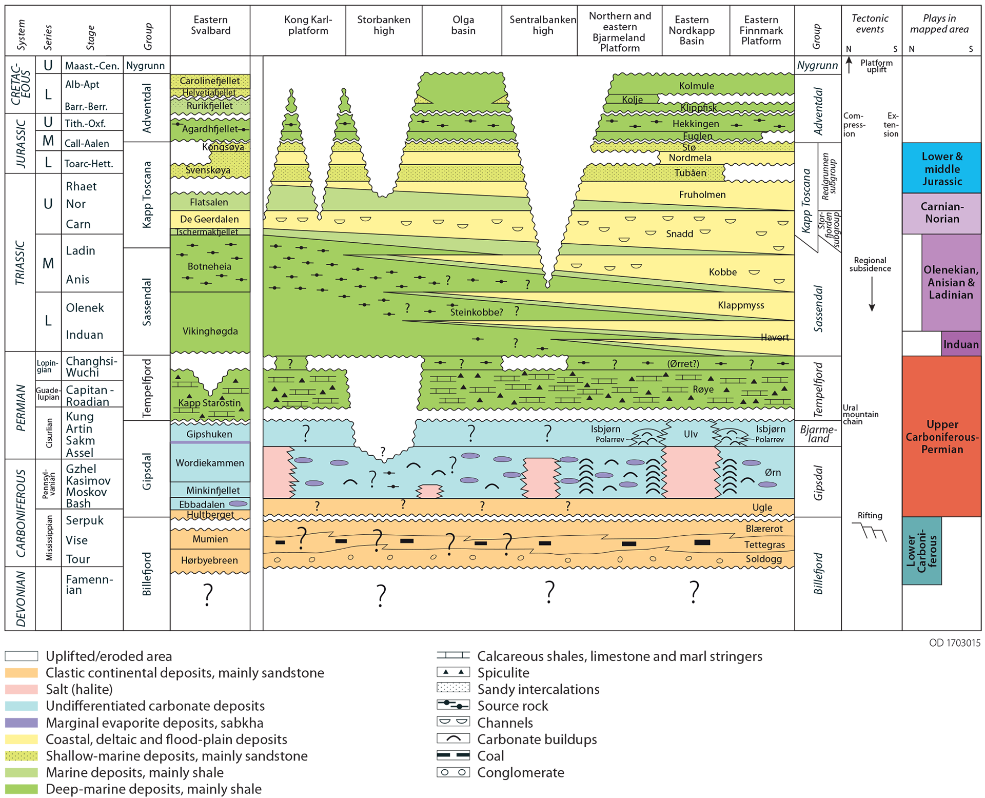
Figure 28.
Chronostratigraphic and lithostratigraphic diagram for the eastern part of Norway’s Barents Sea sector and for eastern Svalbard, modified from http://www.npd.no/en/Topics/Geology/Lithostratigraphy/. Identified plays are shown on the right of the figure.
A number of extremely large geological structures stand out at several geological levels. These are primarily identified on the Sentralbanken high, the Storbanken high and the Kong Karl platform (figure 2). In addition comes a potential for a number of other structures, both large and small, at the various levels. Through the mapping process, the structures were matured to geological traps which were utilised in further play analysis work. The latter has been based on the geological information obtained by assessing the potential for hydrocarbons being present in the various identified traps, as well as possible prospectivity which could be mapped in the future with better data coverage. Figure 29. Extent of the Early Carboniferous play in the mapped area of Barents Sea North.
EARLY CARBONIFEROUS (TOURNAISIAN, VISEAN AND SERPUKHOVIAN) PLAY
The oldest play assessed in the mapped area comprises sandstones and conglomerates deposited as fluvial and alluvial river, delta and floodplain systems in the Early Carboniferous. This play (figure 29) is confined to where the clastic rocks are assumed to have retained their reservoir properties. That is in areas around the Storbanken high, where the maximum burial is assumed to have been less than 4 500 metres.
Figure 29.
Extent of the Early Carboniferous play in the mapped area of Barents Sea North.
The trap type comprises anticlines and fault blocks. In addition, stratigraphic traps could occur locally in fluvial channel systems around the highs. The possible source rock is assumed to be Lower Carboniferous coal and carbonaceous shales (Billefjorden Group). As mentioned above, this source has been deeply buried in much of the area and gas is therefore the most likely hydrocarbon phase in this play.
An analogous play is found on the Finnmark Platform in Barents Sea South.
LATE CARBONIFEROUS-PERMIAN (BASHKIRIAN-GUADALUPIAN) PLAY
Shown in figure 30, this play comprises possible reservoirs of limestones and dolomites in warm-water carbonates (Gipsdalen Group), calcite-dominated cold-water carbonates (Bjarmeland Group), and silicified carbonates and spiculite flint (Tempelfjorden Group). The Gipsdalen Group contains thick carbonate accumulations (palaeoaplysina reefs) from warm, shallow marine waters with proven good reservoir properties in analogue settings (Stemmerik & Worsley, 2005). Large carbonate accumulations (bryozoan reefs) are also found in the Bjarmeland Group, but then from deeper marine, temperate waters. The play is extensive in the mapped area, but is not regarded as relevant in the deeper areas such as the Olga Basin.
Figure 30.
Extent of the Late Carboniferous-Permian play in the mapped area of Barents Sea North.
Frequent and major changes in relative sea level during this period mean that karstification (seen in such places as the Loppa High) could be important for reservoir properties. One restriction on reservoir quality could be that the carbonates have earlier been too deeply buried. Low permeability in deeply buried carbonates may be compensated for in areas where possible fractured reservoirs are found. The trap type comprises anticlines and fault blocks. Stratigraphic traps could also have developed in independent carbonate accumulations throughout the area.
Relevant source rocks for the play are Lower Carboniferous coal and carbonaceous shale (Billefjorden Group), Upper Carboniferous and Lower Permian organic carbon-rich mud (Gipsdalen Group) and possibly Upper Permian marine shales (Tempelfjorden Group). These source rocks have also been deeply buried, which increases the probability of possible gas generation.
The analogous play in Barents Sea South is found in such places as the Loppa High.
EARLY TRIASSIC (INDUAN) PLAY
The play comprising Early Triassic reservoir rocks (figure 31) is assumed to consist of prograding coast/ delta front and possible turbidite sandstones in the slope down towards deeper marine conditions to the north-west of the mapped area. Fluvial sandstones could be relevant reservoir units in the southern part of the area. In the Hopen-2 well, the Early Triassic (Induan) has developed as dark shale without reservoir properties. Seismic interpretation shows that the clinoform systems in the Induan flatten out before they reach Hopen-2, and that this position lies north of the Early Triassic build-out. Typically, clinoform systems in the Early Triassic are large but have low inclinations. This could suggest that the slope has a large content of silt and clay, and that possible reservoir facies lie in the more horizontal layers located over the tilted strata. That also defines the extent of the play.
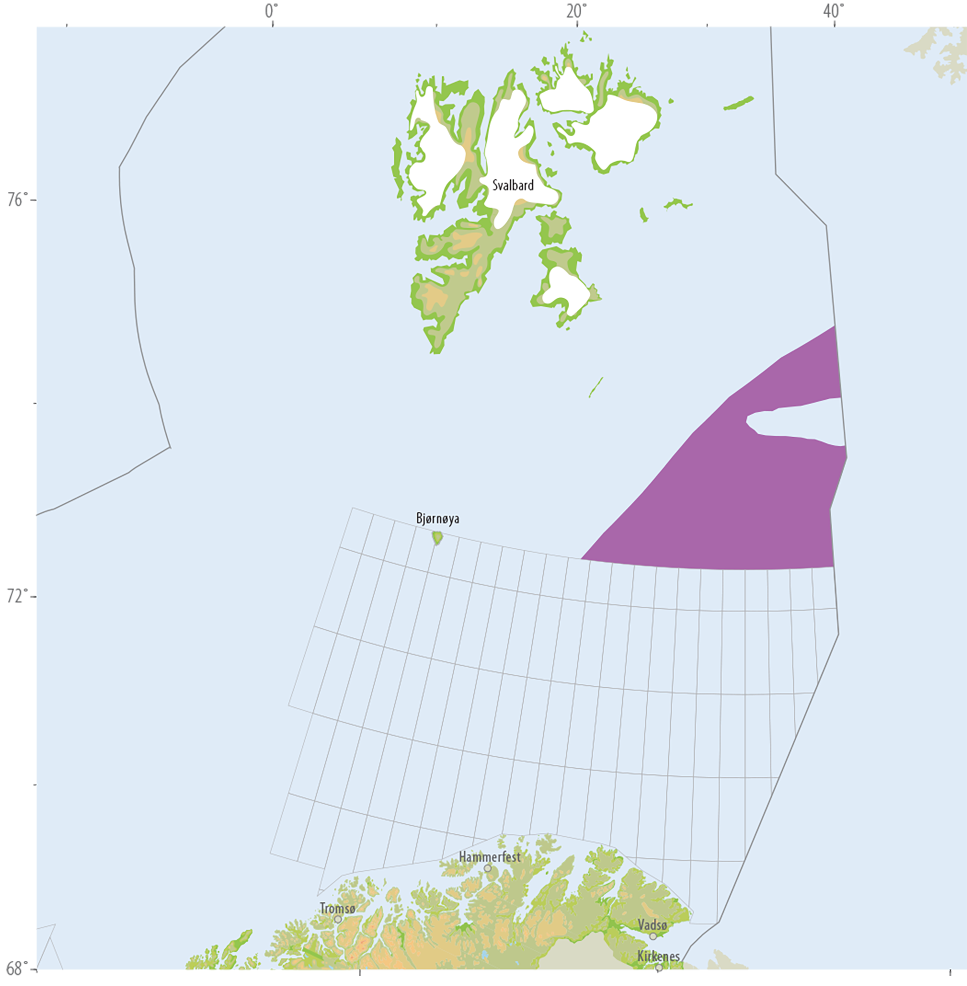
Figure 31.
Extent of the Early Triassic play in the mapped area of Barents Sea North.
The trap type comprises anticlines and fault blocks. Stratigraphic traps may also have developed in fluvial channel systems at the southern end of the area.
Source rocks for the play could be Early Carboniferous coal measures and organically rich shales and carbonates in the Carboniferous and Permian. In addition, organically rich Early Triassic shales cannot be excluded as potential source rocks. The common denominator for these source rocks is that they lie deep over most of the area and have probably passed through the oil window, so that they will possibly generate gas at today’s burial depth. The play is analogous to that for the Havert Formation in the southern part of the Barents Sea, where gas has been proven.
EARLY-MIDDLE TRIASSIC (OLENEKIAN, ANISIAN AND LADINIAN) PLAY
The play comprising Early-Middle Triassic reservoir rocks is assumed to consist of prograding coast/delta front deposits, including estuaries and fluvial channels. The possibility of turbidite deposits in the play area (figure 32) is taken into consideration, but these are expected to have only a limited volume by comparison with the other facies types in the play.
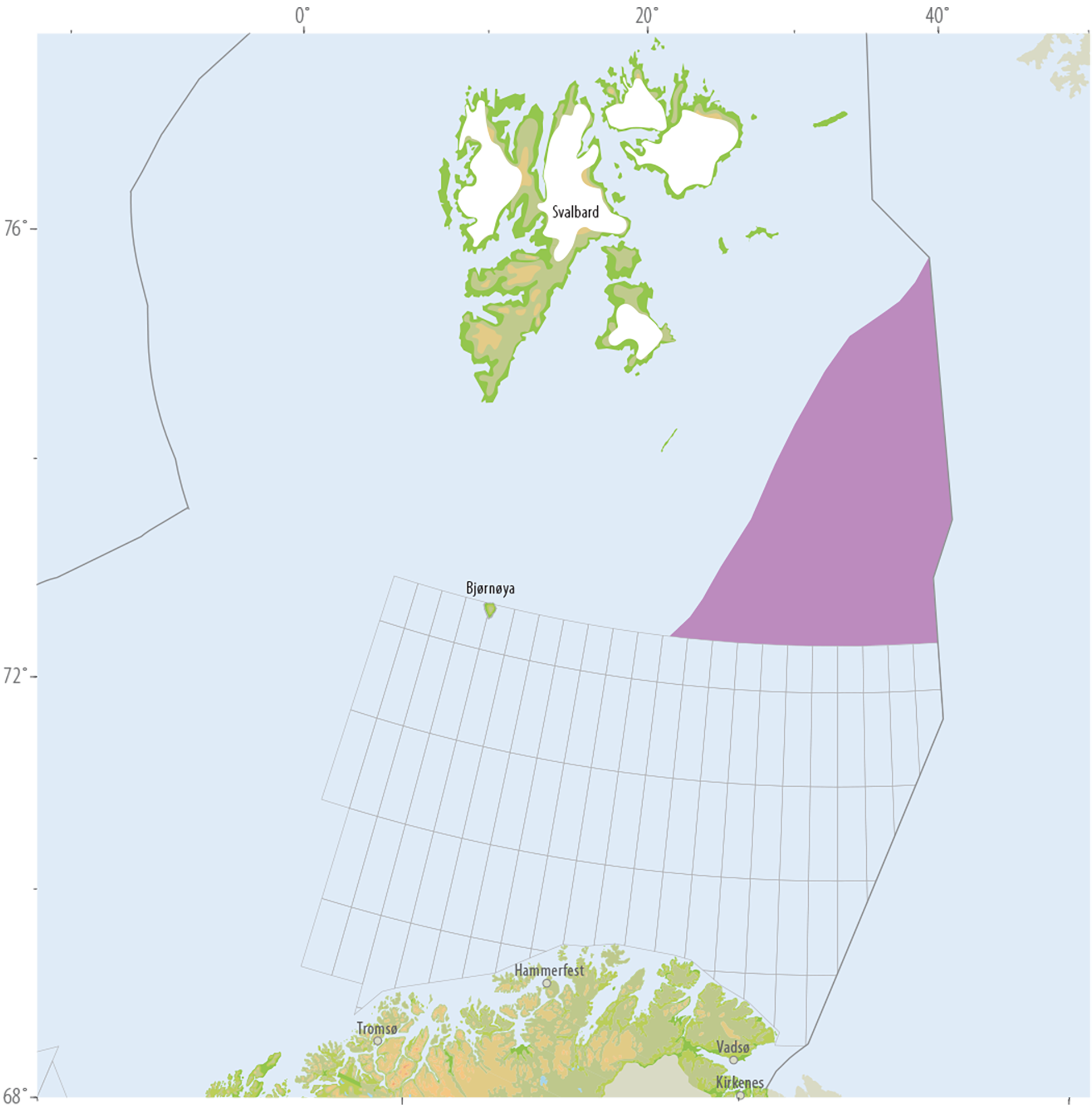
Figure 32.
Extent of the Early-Middle Triassic (Olenekian, Anisian and Ladinian) play in the mapped area of Barents Sea North.
The trap type comprises anticlines and fault blocks. In the upper part of the clinoform systems, wedging out towards the north-west could produce a combined stratigraphic and structural trap. Stratigraphic traps could also be developed in fluvial channel systems in the southern part of the play.
Carbonaceous shales from the Olenekian, Anisian and Ladinian (Steinkobbe/Botneheia Formation) are the most important source rocks. These are expected to be the most important oil-generating source rocks for the play.
Other source rocks for the play might be Early Carboniferous coal measures and organically rich shales and carbonates in the Carboniferous and Permian. These rocks are most likely to have generated gas because of the deep burial of the shales and possible gas-generating coal horizons in the Early Carboniferous. The very uppermost part of Permian, which could be a relevant source rock for the southern Barents Sea, appears to have been eroded over large parts of the area. In addition, Early Triassic shales cannot be excluded as a possible source.
The play is analogous to ones which include the Klappmyss and Kobbe Formation in Barents Sea South, where both oil and gas have been proven to the west.
LATE TRIASSIC (CARNIAN-NORIAN) PLAY
Late Triassic reservoir rocks are also assumed to consist of prograding coast/delta front deposits, including estuaries and fluvial channels. The play for this reservoir level is shown in figure 33.
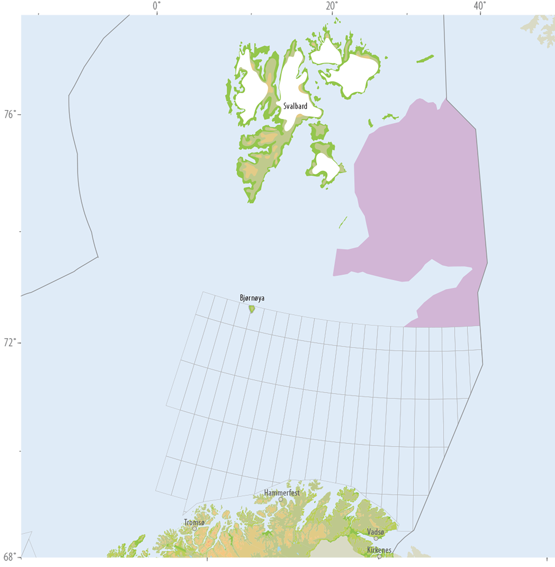
Figure 33.
Extent of the Carnian-Norian play in the mapped area of Barents Sea North.
In lithostratigraphic terms, this correlates with the De Geerdalen Formation in Svalbard and thin sandstones uppermost in the Tschermakfjellet Formation (figure 28). Preliminary results from shallow drilling off Kvitøya in 2015 suggest that sandstones deposited in the Norian could play an important role as reservoir rocks, and that these lie immediately below a Norian marine shale.
The trap type comprises anticlines and fault blocks. In the upper part of the clinoform systems, wedging out towards the north-west could produce a combined stratigraphic and structural trap. Stratigraphic traps could also be developed in fluvial channel systems in the southern part of the play. Small structural traps could have been formed from synsedimentary tectonic processes in unconsolidated rocks, as seen at Kvalpynten and Klinkhamaren in Edgeøya. These are regarded in this study as small structures which would lie far below the seismic resolution of the available 2D data.
The source potential is very similar to that for plays in the Early-Middle Triassic, but internal sources are also possible. Again, the most important source rock for this play is the Steinkobbe/Botneheia Formation, as described above. In addition, the possibility exists for internally generated gas from coal measures and much organic plant material in large parts of the sedimentary succession.
An analogous play has been proven in Barents Sea South with both multiphase and gas discoveries.
EARLY-MIDDLE JURASSIC PLAY
The play (figure 34) with Early-Middle Jurassic reservoir rocks is assumed to consist of prograding coast/delta front deposits, including estuaries and fluvial channels.
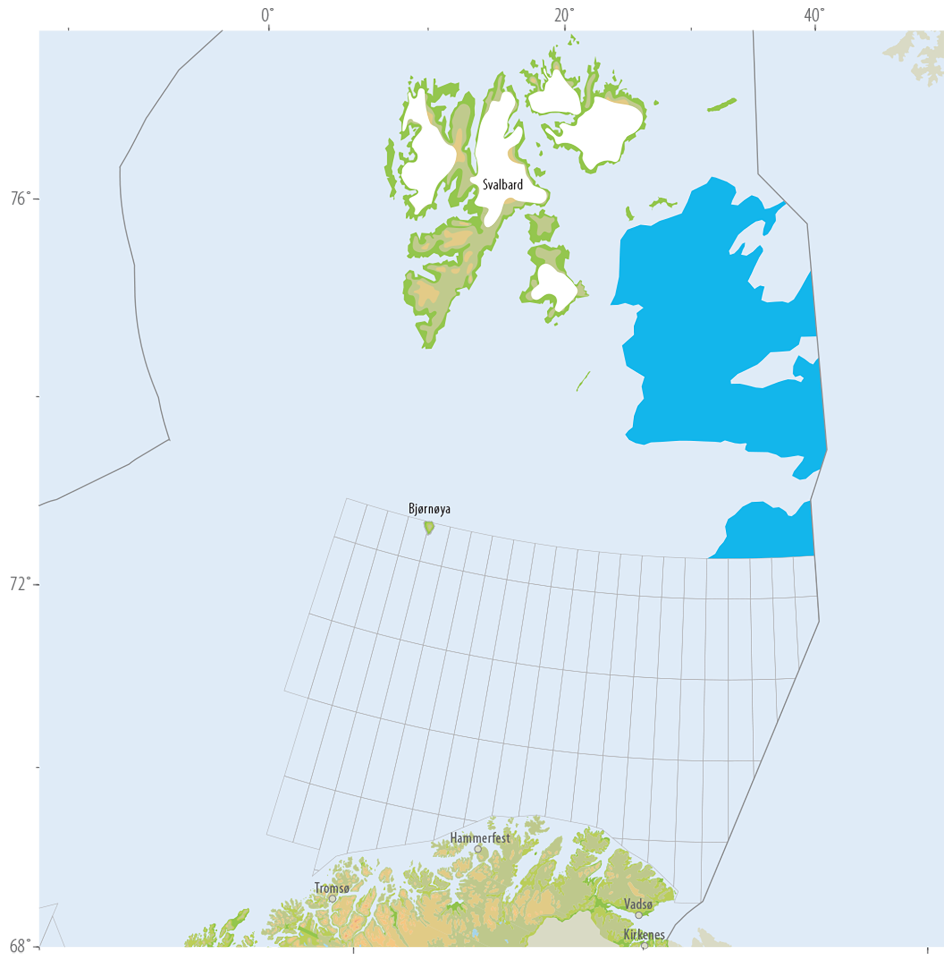
Figure 34.
Extent of the Early-Middle Jurassic play in the mapped area of Barents Sea North.
In lithographic terms, the play correlates in the northern Barents Sea with the Svenskøya and Kongsøya Formation (figure 28). Parallels can be drawn in the southern part of the area with the Realgrunnen subgroup. Attribute analysis of this subgroup on the Haapet Dome using 3D seismic data has shown the presence here of a well-developed fluvial channel system with sediment input assumed to be clastic from the southeast. These channel systems are very likely to continue northwards. From Kong Karls Land, the Middle Jurassic has developed with continuous unconsolidated sandstones, and the reservoir quality is thought to be very good.
The trap type comprises large anticlines and small fault blocks, which can occur in large numbers in certain areas.
Where this play is concerned, the source potential will be the same as that for the Late Triassic play. The main source for oil is assumed to be the Steinkobbe/Botneheia Formation, while Palaeozoic source rocks and other Triassic source rocks have a greater potential for gas.
Analogous plays in Barents Sea South have been proven for both oil and gas. Discoveries in the play form part of both the Goliat and Snøhvit fields.